34
Pictures from the Past
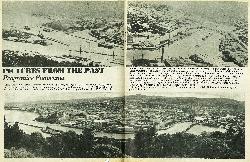
Progressive Panorama
From Mrs R. J. Sisterson, Aberdeen Road, come these two photographs which almost form a continuous panorama of Gisborne. They were taken, as far as can be estimated, in 1927. The dredging of the cut was finished on July 1 of that year, while Butler's Wall was completed in October, 1929. Since then, of course, the overseas harbour basin has been formed (eliminating that triangle of land at left), the Waikanae Beach Camping Ground has grown, J. Wattie Canneries now occupy a large area in the centre of the picture, the railway bridge over the Turanganui River completed, not to mention the construction of the inner harbour basin, which became available to shipping in 1932. We may be stating an obvious fact but it is interesting to note that all the inner harbour work, devised and constructed over a number of years, was necessary if Gisborne was to continue receiving coastal shipping. Dredges provided ample depth and anchorage in the river mouth but every few years big floods would come along and silt up the whole works, sometimes raising the depth of the river basin floor from 17 or 18 feet to four or five!


